 Skip-the-line available
 What to See at Petra: A Walking Guide to the Nabataean City
A monument-by-monument guide through the Petra archaeological park — the Siq, the Treasury, the Royal Tombs, the High Place of Sacrifice, the Monastery and the quieter trails most visitors miss.
The Petra archaeological park covers 264 square kilometres, but the visitor experience compresses into a series of named monuments along a roughly linear walking route from the Petra Visitor Centre at Wadi Musa to the Qasr al-Bint area in the heart of the basin, with branching trails to the major upper sites. First-time visitors regularly underestimate how much there is to see and overestimate how much can fit into a single day. This guide walks through the park in the order most visitors actually encounter the monuments, with the historical context, the time investment, and the trail-junction decisions that shape what you see. The single-day route covers the Siq, the Treasury, the Outer Siq, the Royal Tombs, the Roman Theatre, the colonnaded street, and a partial Monastery climb. A second day opens the High Place of Sacrifice, the full Monastery, and the quieter Wadi Farasa loop. A third day adds Little Petra, Wadi Muthlim, and Jebel Haroun for the determined.
The Bab as-Siq Approach and the Djinn Blocks
The walk from the Petra Visitor Centre to the Siq entrance is approximately 800 metres of open valley path called the Bab as-Siq (Gate of the Siq). The route descends gently along a hard-packed earth and gravel track, with the high cliffs of the main massif rising to the north and a broad terrace to the south. Most visitors rush this section, which is a mistake — the Bab as-Siq holds several monuments that establish the visual vocabulary of what is to come. The three free-standing stone cubes carved from the surrounding rock, known as the Djinn Blocks, are the first encounter; their original purpose remains debated, with proposals ranging from grave markers to symbolic representations of Nabataean deities. They date from the 1st century BC.
Beyond the Djinn Blocks, the path passes the Obelisk Tomb on the left — a hybrid Nabataean facade with four pyramidal obelisks above a Hellenistic-style triclinium dining chamber below — and the Aslah Triclinium nearby, dated by inscription to 96 BC and one of the oldest dated Nabataean monuments in the park. Horse-drawn carriages run this section as a paid shuttle service for visitors who want to skip the walk; the standard advice is to walk in and shuttle out, preserving the energy of the morning for the Siq itself. By 09:00 the Bab as-Siq carries a steady flow of carriages, horse riders, and walkers in both directions; the 06:00 first-entry slot finds the path empty and the morning light still cool on the cliffs.
The Siq: 1.2 Kilometres of Carved Canyon
The Siq is the narrow natural fissure that serves as the only entrance to the main Petra basin — a 1.2-kilometre cleft in the sandstone created by tectonic movement and subsequently shaped by water erosion. At its narrowest points it is barely three metres wide; the cliffs rise more than 80 metres overhead, occasionally closing overhead and reopening to admit narrow slants of sunlight. The walk takes 20–25 minutes at a steady pace, longer if you stop to examine the carved water channels running along both walls. The right-hand channel was a ceramic-piped clean-water system carrying water from the Ain Musa spring at Wadi Musa into the city; the left-hand open channel handled flash-flood runoff. Small terracotta pipe segments remain in situ along several sections. This twin-channel hydraulic engineering is one of the reasons UNESCO inscribed Petra under criterion iii.
Along the Siq, watch for carved niches that once held small cult-statues of Nabataean deities — Dushara, Al-Uzza, and the trio-figure betyl stones used as aniconic representations of the divine. The carved Camel Caravan relief at one of the wider sections, partially eroded, depicts merchants and pack camels and gives a sense of the ceremonial-procession use of the Siq in Nabataean religious life. The Siq is shared with the horse-cart shuttle service that runs between the Visitor Centre and the Treasury — keep to the side when you hear hooves and the drivers shouting in Arabic, and resist the temptation to take a carriage in: walking the Siq is the experience for which most visitors come.
The Treasury (Al-Khazneh): The Reveal at the End of the Siq
The Siq ends in a slit-thin gap that frames the Treasury (Al-Khazneh) as the visitor approaches — a 24-metre wide, 39-metre tall Hellenistic facade carved directly into the rose-pink sandstone cliff. The reveal is the photograph everyone has seen, and the structured anticipation of the approach makes it work on every visitor regardless of how many images they have already encountered. Built in the early 1st century AD, almost certainly as the mausoleum of Nabataean King Aretas IV (9 BC – 40 AD), it earned its modern name from a Bedouin legend that the urn at the top concealed a pharaoh's gold; bullet marks visible on the urn are from 19th- and 20th-century treasure-hunters firing at it from below in attempts to release the supposed treasure. The interior chamber is no longer accessible to visitors, and has not been since 2003.
The Treasury plaza is the busiest spot in the park between 09:00 and 14:00 in peak season; the cleanest reveal comes with 06:00 first entry or after 16:00 when most coach groups have moved on. The facade catches direct sun between roughly 09:30 and 11:30 in winter (slightly later in summer); outside that window the rose colour is softer but the carved details — the Corinthian columns, the central tholos with its conical roof, the eagles and Amazon figures in the upper register — are visible without harsh shadow. The view of the Treasury from above, reached by a steep Bedouin trail behind and to the right of the facade, has become one of the most-photographed Petra angles in recent years; expect a Bedouin-guided ascent fee per person, and decide before you mount whether the time investment is worth it for your day.
The Outer Siq, Royal Tombs and the Roman Theatre
Beyond the Treasury the path opens into the Outer Siq — a broader valley flanked by carved tombs on both sides as the route descends toward the Roman Theatre and the colonnaded street. The cliff face to the north holds the Street of Facades, a row of Nabataean tower-tombs carved with simple stepped pediments dating from the 1st century BC to the 1st century AD. Beyond, the path swings right toward the cluster known as the Royal Tombs: the Urn Tomb (converted to a Christian church in 446 AD, with the dedicatory inscription still visible inside), the Silk Tomb (named for the colour-banded sandstone of its facade), the Corinthian Tomb (a Treasury-style Hellenistic facade in a more weathered state), and the Palace Tomb (Petra's largest tomb facade, five storeys tall but partially collapsed at the upper levels).
Opposite the Royal Tombs cluster, the Roman Theatre is carved into the rock face with seating for approximately 8,500 spectators across three tiers. Built originally by the Nabataeans in the 1st century AD and substantially renovated after the Roman annexation in 106 AD, it is one of the most striking examples of a theatre cut directly from living rock rather than constructed. Beyond the theatre, the colonnaded Roman street runs west toward the Qasr al-Bint area — Petra's Roman and Byzantine commercial spine. The Great Temple, a major Nabataean religious complex partly excavated by Brown University since 1993, sits on the south side of the street. By the time you reach Qasr al-Bint, you are at the foot of the Monastery climb and the decision point for whether to push on uphill or to circle back and end the day.
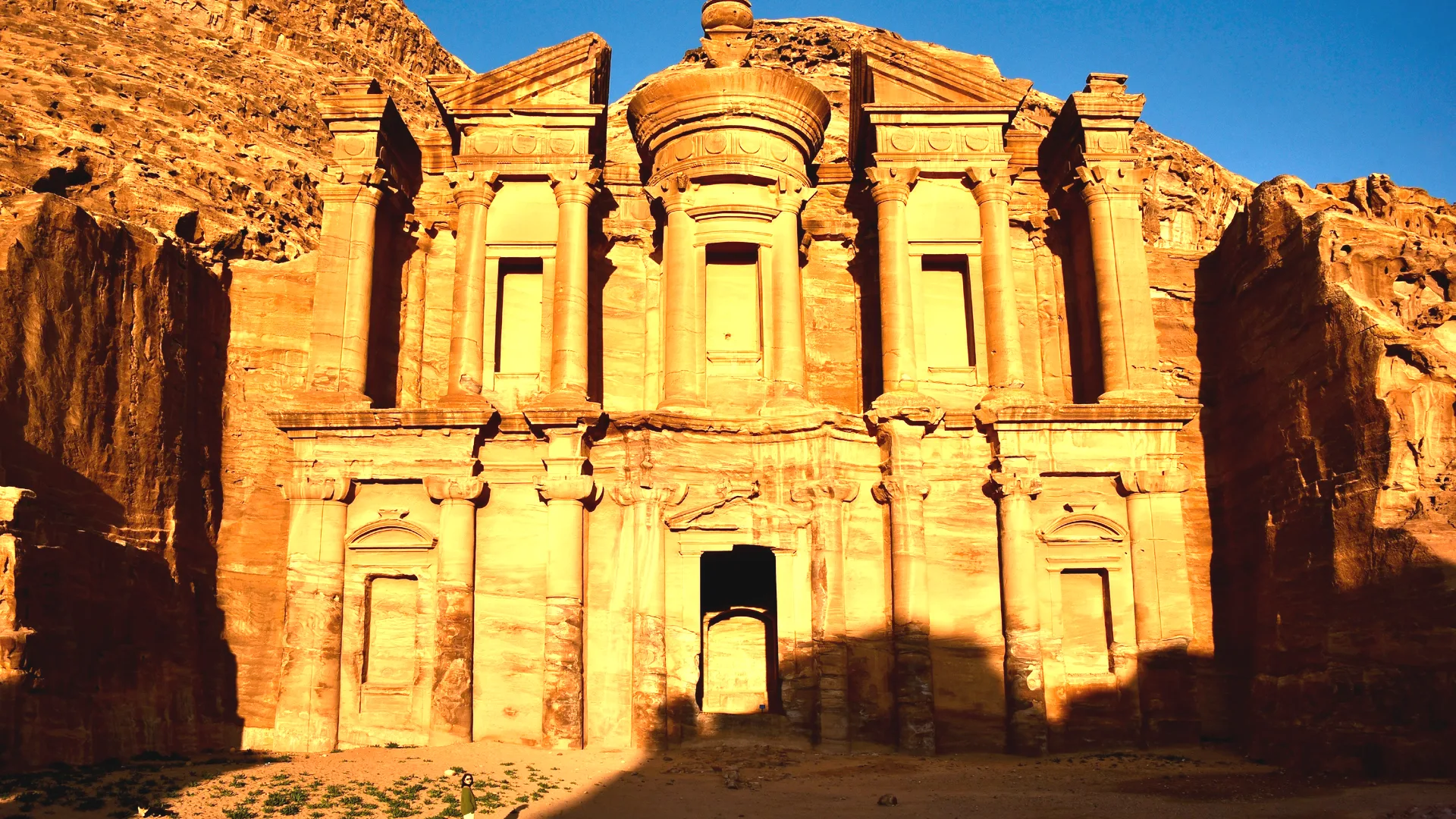
The Monastery (Ad Deir): The 800-Step Climb
The Monastery is Petra's largest carved monument — 47 metres wide and 48 metres tall, larger than the Treasury — and the most rewarding climb in the park. The trail begins at the back of the Qasr al-Bint area, climbing approximately 800 rock-cut steps through Wadi Kharrarib, gaining about 220 metres of elevation. Allow 45–75 minutes up depending on fitness and weather, and 30–45 minutes down. The trail is well-defined, with shaded rest stops and Bedouin tea stalls along the way; donkeys are available at the bottom and at staging points for visitors who prefer to ride up. The strong recommendation is to walk down regardless of how you go up — the descending views are remarkable, and donkeys descending the steep sections is uncomfortable for everyone involved.
Despite its modern name, the Monastery was almost certainly a Nabataean ceremonial banqueting hall, probably dedicated to the deified Nabataean king Obodas I; the crosses scratched into the interior chamber walls date from a brief Byzantine repurposing centuries after Petra's commercial peak. The facade itself is more austere than the Treasury — fewer Hellenistic decorative details, more emphasis on raw scale — and the courtyard in front is large enough to take in the full elevation in a single sweep. Five minutes' walk past the Monastery brings you to a clifftop viewpoint over the Wadi Araba valley, with the mountains of Israel visible across the rift on clear days. This viewpoint is the photograph many visitors miss because they leave before they realise it exists; if you climb the Monastery, do not leave without walking the extra five minutes.
The High Place of Sacrifice and the Wadi Farasa Loop
The High Place of Sacrifice (Al-Madbah) is the shorter, steeper alternative to the Monastery and the strongest second-day climb at Petra. The trail begins near the Roman Theatre, climbs approximately 200 metres in roughly 800 steps, and ends on a flat ridge atop Jebel Madbah with two carved obelisks and a Nabataean sacrificial altar still preserved with its drainage channels for ritual liquids. The summit gives a 360-degree view across the entire main basin — Treasury, Theatre, Royal Tombs, Colonnaded Street, Monastery cliff in the distance — that is impossible to appreciate from the valley floor. The ascent takes 30–45 minutes; allow 15–20 minutes on the summit for the views and photography.
Rather than descending the same trail, the strongly preferred route is the Wadi Farasa loop: a Bedouin trail dropping the western side of the ridge past a sequence of monuments most visitors never see. The Lion Fountain (a worn lion carving that once served as a spring-fed drinking trough), the Garden Tomb (a Nabataean tomb facade set against a lush rock-pool), the Renaissance Tomb, the Soldier's Tomb (named for the carved military figures on its facade), and the Roman Tomb appear in sequence before the trail loops back to the colonnaded street near the Theatre. The Wadi Farasa loop turns the High Place into a half-day route rather than a sequence of out-and-back climbs, and is the single best half-day inside Petra for visitors who only have one day and want depth beyond the Treasury.
Frequently asked
What are the must-see monuments at Petra?
The Siq, the Treasury (Al-Khazneh), the Royal Tombs (Urn, Silk, Corinthian, Palace), the Roman Theatre, and the Monastery (Ad Deir). A second day adds the High Place of Sacrifice and the Wadi Farasa loop; a third day adds Little Petra and Wadi Muthlim.
How long is the walk from the visitor centre to the Treasury?
About 2 kilometres — 800 metres of open Bab as-Siq path, then 1.2 km through the Siq itself. Allow 25–35 minutes at a comfortable pace including photo stops. The path is hard-packed earth and original Nabataean paving stones.
Is the Treasury interior open to visitors?
No. The interior chamber has been closed to all visitors since 2003 to protect the carved sandstone. The Treasury is experienced from the plaza in front, and from the elevated Bedouin viewpoint above the canyon (accessed via a separate guided ascent at a fixed per-person fee).
What is the Monastery and how do you reach it?
The Monastery (Ad Deir) is Petra's largest carved monument — 47m wide × 48m tall — reached by an 800-step climb from the Qasr al-Bint area. The climb gains 220 metres of elevation; allow 45–75 minutes up and 30–45 minutes down.
Are the Royal Tombs worth a separate visit?
Yes — they sit on the main route between the Treasury and the Roman Theatre, so they are passed naturally on any one-day visit. The Urn Tomb retains its 446 AD Christian-church dedicatory inscription inside; the Silk Tomb shows the colour-banded sandstone that gives Petra its rose-red reputation.
How many steps is the High Place of Sacrifice climb?
Approximately 800 rock-cut steps, gaining 200 metres of elevation, taking 30–45 minutes up. Descend via the Wadi Farasa loop past the Lion Fountain and Garden Tomb for the best half-day route inside Petra.
What is Little Petra?
Little Petra (Siq al-Barid, the Cold Canyon) is a smaller Nabataean settlement about 9 km north of the main park — a 15-minute drive. It was a trading suburb where caravans stopped before entering Petra proper. Entry is currently free, the site is rarely crowded, and it includes carved facades, dining triclinia and a restored Hellenistic painted ceiling.
Can I see the Treasury from above?
Yes — a Bedouin-guided trail climbs to a clifftop viewpoint above the Treasury, a fixed per-person fee for the ascent. The view is genuine and the photograph is excellent, but the negotiation at the Siq exit can be hard-pressure. Decide in advance whether the time investment fits your day.
Are there cafés and restrooms inside Petra?
Yes — basic cafés and restrooms at the Royal Tombs area, near Qasr al-Bint, and at the foot of the Monastery climb. Bring more water than you expect to need; a refillable bottle is fine. The walk back from the Monastery to the visitor centre is 4+ kilometres.
What is the best monument to photograph at Petra?
The Treasury reveal from the inside end of the Siq is the iconic shot — the facade emerges in the gap a column at a time. Best light: 08:00–09:30 morning sun on the upper façade. The other classic is the view from the Monastery viewpoint over Wadi Araba toward Israel in late afternoon.